The project included the feasibility study, detailed engineering survey, design and preparation of DPR, environmental and
Social study for improvement of the road sections, preparation of procurement documents for the following Highways:
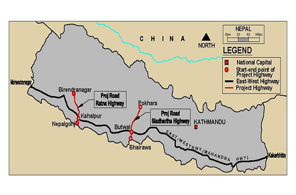
Kohalpur – Surkhet Road (Ratna Highway, H012) – 90.75 km and Butwal – Pokhara Road Section of Siddhartha Highway, H10 – 157.20 km.
Nepal’s highway system’s backbone is it’s East-West Highway (1027 km), also called Mahendra Highway, which stretches the entire length of the country in the Terai Region close and parallel to its border with India. A number of highways, including two project roads – the Ratna Highway (90.75 km) and Siddhartha Highway (157.20 km), running transverse to it, join/intersect Mahendra Highway at various points.
The Ratna Highway connects Nepalganj-Rupendia land port with India, Uttar Pradesh on the west and Birendaranagar (Surkhet), district HQ and capital of Province-6 on the east. The road passes through plains, rolling and hilly terrains of Lesser Himalyan Range gradually rising upto 1740m from the mean sea level and will finally connect Mansaravar in Tibet. Also connects several tourist attractions, river points including Bardia and Banke National Parks, mountain trekking, river rafting in Bheri River, Lots of heritage temples and monuments. This is very important to bring economic development to the remote and poor hilly regions in the northeast of Nepal.
The Siddhartha Highway connects Butwal Town (Shiddarthnagar) containing Bairawa landport with India on the west and Pokhara, tourism capital on the east. The road passes through the Chure and Mahabharat Ranges upto 4000m height. The road is second best lifetime of Nepal connecting rapidly growing city in the Centre of Terai with Pokhara, the second largest and tourism city of Nepal.
BCL in JV with HIFAB of Sweden was the consultant for this ADB funded project.
Client: Department of Roads, Nepal, 2017


